How Many Counties in Ireland? 32 Counties Explained
Anyone who has ever looked at a map of Ireland has noticed its patchwork of counties — a system that dates back centuries and still shapes identity today. There are 32 counties across the island, split between the Republic of Ireland (26) and Northern Ireland (6).
Total counties on island of Ireland: 32 ·
Counties in Republic of Ireland: 26 ·
Counties in Northern Ireland: 6 ·
Largest county by area: Cork ·
Smallest county by area: Louth ·
Most populous county: Dublin
Quick snapshot
- The island has 32 traditional counties (Ireland.com — Ireland’s official tourism body).
- 26 counties form the Republic of Ireland (Ireland.com — Ireland’s official tourism body). (Ireland.com — Ireland’s official tourism body)
- 6 counties make up Northern Ireland (Ireland.com — Ireland’s official tourism body). (Ireland.com — Ireland’s official tourism body)
- Which county is “most forgotten” is subjective — Leitrim is often named but has no official designation.
- The “prettiest town” changes with tourism awards and personal taste.
- 12th century: Norman invasion introduced first county divisions (Wikipedia — Counties of Ireland).
- 1898: Local Government (Ireland) Act formalised counties as administrative units (Wikipedia — Counties of Ireland).
- 1921: Partition created Northern Ireland (6 counties) and the Irish Free State (26 counties) (Wikipedia — Counties of Ireland).
- Modern local-government reforms in both jurisdictions continue to adjust boundaries and functions.
- The 32-county identity remains strong in GAA sports, tourism branding, and diaspora genealogy.
The 32 counties break into a clear numeric picture — here’s the quick reference:
| Label | Value |
|---|---|
| Total counties | 32 |
| Republic of Ireland | 26 counties |
| Northern Ireland | 6 counties |
| Largest county (area) | Cork (7,499 km²) |
| Smallest county (area) | Louth (826 km²) |
| Most populous county | Dublin (1.45 million) |
Are there 32 counties in Ireland?
Yes — the island of Ireland has exactly 32 traditional counties, a number that dates back to the Norman era and was solidified in the 19th century (Ireland.com — Ireland’s official tourism body). After the partition of 1921, 26 of these counties became the Republic of Ireland (an independent sovereign state) and six became Northern Ireland, a constituent country of the United Kingdom (Wikipedia — the free encyclopedia).
What is the difference between the Republic of Ireland and Northern Ireland?
- Republic of Ireland: 26 counties, independent since 1922, uses counties as local-government units (with some modern administrative divisions).
- Northern Ireland: 6 counties (Antrim, Armagh, Down, Fermanagh, Londonderry, Tyrone) — counties ceased to be used for local government there in 1973 (Wikipedia — the free encyclopedia).
How many counties are in each province?
Ireland is divided into four provinces, each containing a specific number of the 32 counties:
- Leinster: 12 counties
- Munster: 6 counties
- Connacht: 5 counties
- Ulster: 9 counties (3 in the Republic — Cavan, Donegal, Monaghan — and 6 in Northern Ireland) (Ireland.com — Ireland’s official tourism body)
Why this matters: the province-county system is embedded in everyday Irish life — from postal addresses to sports rivalries. Ask any Irish person their county and you’ll get a story, often tied to one of the four provincial cups in GAA.
For the Irish diaspora and sports fans, the 32 counties remain the map that matters. A Cork hurler doesn’t see a 26-county Republic — he plays for his traditional county, part of the full 32.
The implication: understanding this distinction clarifies why political borders don’t fully capture Irish identity — the 32-county model persists in GAA, genealogy, and everyday pride.
What are the 32 counties in Ireland?
Here they are — all 32, grouped by province, with their current country affiliation. The full list covers every county on the island (Ireland.com — Ireland’s counties and provinces).
Alphabetical list of all 32 counties
Republic of Ireland (26): Carlow, Cavan, Clare, Cork, Donegal, Dublin, Galway, Kerry, Kildare, Kilkenny, Laois, Leitrim, Limerick, Longford, Louth, Mayo, Meath, Monaghan, Offaly, Roscommon, Sligo, Tipperary, Waterford, Westmeath, Wexford, Wicklow.
Northern Ireland (6): Antrim, Armagh, Down, Fermanagh, Londonderry, Tyrone (Wikipedia — the free encyclopedia).
List by province
Each province groups its counties — here’s the full breakdown:
| Province | Counties |
|---|---|
| Connacht | Galway, Leitrim, Mayo, Roscommon, Sligo |
| Leinster | Carlow, Dublin, Kildare, Kilkenny, Laois, Longford, Louth, Meath, Offaly, Westmeath, Wexford, Wicklow |
| Munster | Clare, Cork, Kerry, Limerick, Tipperary, Waterford |
| Ulster | Antrim, Armagh, Cavan, Donegal, Down, Fermanagh, Londonderry, Monaghan, Tyrone |
The implication: if you’re planning a road trip or researching ancestry, knowing the province group helps narrow your search. For example, “County Mayo” immediately places you in Connacht, famous for its rugged coastline and pilgrimage mountain Croagh Patrick.
Irish genealogical records are often organised by county and province. If your ancestor emigrated from “County Cork” you’ll be searching the Munster records — not the whole island.
The pattern: province groupings simplify travel planning and ancestry research — they’re the key to unlocking Ireland’s local records and landscapes.
What is the third biggest county in Ireland?
The third largest county on the island by area is Galway, covering 6,148 km² (Wikipedia — List of Irish counties by area). First is Cork (7,499 km²), second is Mayo (5,585 km²).
Top 5 largest counties by area
Here are the five biggest counties by land area:
| Rank | County | Area (km²) |
|---|---|---|
| 1 | Cork | 7,499 |
| 2 | Mayo | 5,585 |
| 3 | Galway | 6,148 |
| 4 | Donegal | 4,861 |
| 5 | Kerry | 4,807 |
The trade-off: big counties like Cork and Galway offer the most diverse landscapes — coast, mountains, farmland — but smaller counties like Louth (826 km²) are easier to explore in a weekend (Wikipedia — List of Irish counties by area).
The catch: size doesn’t equal experience — Louth packs history and coastline into a compact area, making it ideal for short trips.
What is the most forgotten county in Ireland?
In online forums and travel polls, Leitrim is consistently mentioned as the most “forgotten” county (Wikipedia — County Leitrim). It has the smallest population of any county (about 32,000) and is one of the least visited. Other contenders include Longford and Monaghan.
Factors that make a county “forgotten”
- Low population: Leitrim’s population density is the lowest in the Republic.
- Limited tourism infrastructure: Few major attractions compared to Kerry or Cork.
- Off the main travel routes: No major airports or motorways pass through.
The catch: “forgotten” doesn’t mean unworthy. Leitrim has hidden gems — the Shannon-Erne Waterway, Glencar Waterfall — for travellers who venture off the beaten path.
What’s the prettiest town in Ireland?
Beauty is subjective, but a handful of towns consistently top lists. Kinsale (Cork), Dingle (Kerry), Westport (Mayo), and Adare (Limerick) are frequent winners in tourism awards (Wikipedia — List of towns in the Republic of Ireland).
Top towns by county
- Kinsale, Cork: Colourful harbour town, praised for its food scene.
- Dingle, Kerry: Gaeltacht (Irish-speaking) town with dramatic coastal views.
- Westport, Mayo: Georgian architecture, tree-lined streets, Croagh Patrick backdrop.
- Adare, Limerick: Thatched cottages and medieval churches.
For visitors choosing between these, the decision often comes down to what you value most — seafood (Kinsale), Irish language and music (Dingle), walking trails (Westport), or historic charm (Adare).
Summary: Why the 32 counties still matter
Whether you’re tracing your great-grandparents or planning a trip, the 32-county framework is more than a list — it’s a cultural compass. In GAA, counties compete in the All-Ireland championships regardless of the border. In genealogy, a county name is the key to parish records. For the traveller, each of the 32 offers a distinct flavour of landscape and hospitality. The modern political split into 26+6 is a reality, but the 32 remain the map that most Irish people carry in their heads.
“The 32 traditional counties are the basic unit of Irish identity — in sport, in local pride, and in the diaspora’s search for roots.”
— Wikipedia, ‘Counties of Ireland’ (Source)
“Each of the 32 counties has its own unique charms and traditions, making the island a patchwork of distinct experiences.”
— Ireland.com, Ireland’s counties and provinces (Source)
en.wikipedia.org, geoguessr.com, irish-genealogy-toolkit.com, youtube.com
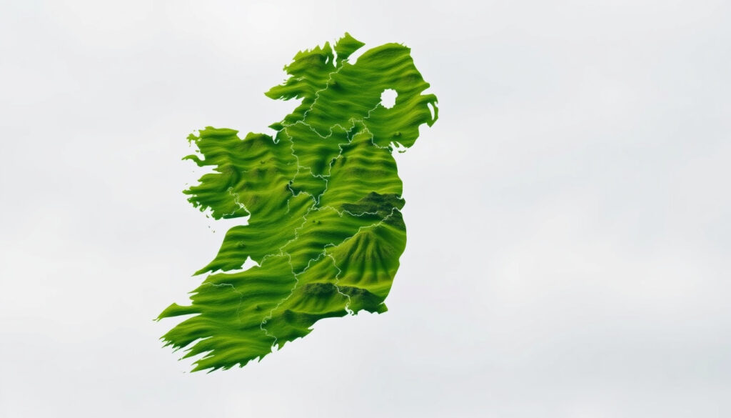
For a visual reference, you can explore a detailed county map of Ireland that shows all 32 counties.
Frequently asked questions
What is the smallest county in Ireland?
Louth is the smallest by area (826 km²). By population, Leitrim is the smallest (about 32,000).
Which county has the most people?
Dublin, with a population of approximately 1.45 million.
What are the four provinces of Ireland?
Connacht, Leinster, Munster, and Ulster.
How were Irish counties created?
The Norman invasion in the 12th century introduced the first divisions. The boundaries were formalised in the 16th–19th centuries, with the Local Government (Ireland) Act 1898 creating the modern administrative map.
What is the oldest county in Ireland?
There’s no official oldest, but County Cork and County Dublin are among the earliest recorded from the 12th century.
Are County Tipperary split into two administrative areas?
Yes — Tipperary is divided into North Tipperary and South Tipperary for local government purposes.
Why is County Dublin divided into three local authorities?
Dublin City, Dún Laoghaire–Rathdown, Fingal, and South Dublin are the four local government areas that replaced the historical county of Dublin for administrative reasons in 1994.
More related posts
 David O’Callaghan Missing: Body Found in Boyle Co Roscommon
 How to Make Yogurt at Home: Easy Step-by-Step Guide with Tips
 Is Hand Foot and Mouth Contagious? Transmission Guide
 Pain on Top of Foot: Causes, Relief, and When to See a Doctor
 Olivia Dean Dublin Tickets 2026: Marlay Park, Prices & On-Sale
 Dining Table and Chairs Ireland – Top Picks and Buying Guide
 Irish Share Prices Today: Live ISEQ, BOI, AIB & More